 Sereno Routing guide
3. Routing in depth
What the New route form can do, how to change a route and run it again, and what to do when one doesn't come out cleanly.
Choosing and comparing models
Each model you tick gets a route of its own, searched separately on that model's forecast and drawn on the same map:
- GFS (NOAA, United States). Drawn solid, colored blue in tables and graphs.
- ECMWF (the European Centre for Medium-Range Weather Forecasts). Drawn dashed, orange.
- AIFS (ECMWF's machine-learning model). Drawn dotted, purple. It has no wave forecast.
Where the routes run close together and arrive at about the same time, the forecasts agree and the plan is on firmer ground. Where they split, the weather is less certain, and the route you sail is likely to be different from any of them. The routes list says how far apart the tracks run (Tracks 10.9 nm apart at most, 5.5 nm on average), and the Data face's Summary and Graph tabs put the models side by side.
The router searches the models at the same time when it has the cores free, so a route with three models usually takes about as long as its slowest model. When the router is busy, a model waits its turn.
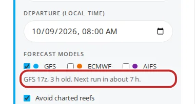
Under the model boxes, a line says how old each model's forecast is and when the next is due, for example GFS 06z, 3 h old. Next run in about 2 h. A run that's later than usual shows in amber. There's no need to wait for it: a route runs on the newest forecast held, and Rerun, latest weather sails it again on a newer one later.
Departure time
Departure (local time) is in your device's time zone; the PDF and tables show the same local times. The forecast has to reach from the departure to the arrival. GFS reaches about 16 days ahead, ECMWF and AIFS about 15 (ECMWF's 06z and 18z runs reach 6 days). A route that runs past the end of the forecast is planned as far as the forecast reaches, and the rest is shown as an estimate (see Partial routes).
A departure before the newest forecast run starts is refused, with the earliest time it can use.
The route's options
Below the models, the form holds the options for this route. Each starts from your boat's settings, says Follows the boat until you change it, and has Use the boat's settings to put it back. Changes here are for this route only.
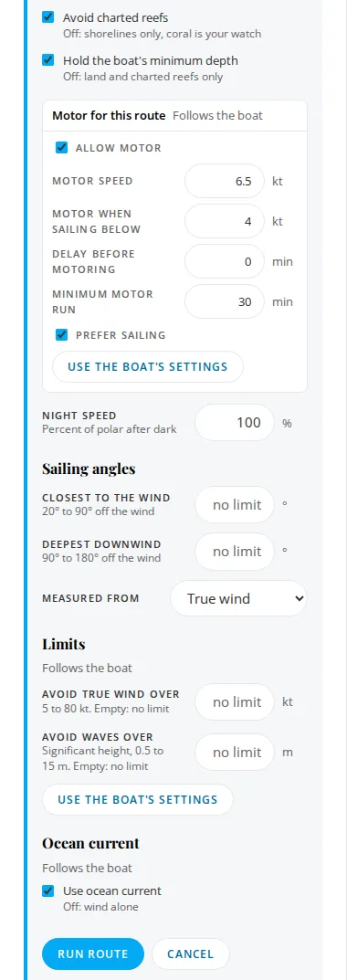
| Option | What it does |
|---|---|
| Avoid charted reefs | On, the router fetches the charted reef shapes along the way and keeps out of them. Off, it plans on shorelines only, and coral is your watch. |
| Hold the boat's minimum depth | On, routes keep to water at least as deep as Settings, Boat says. Off, only land and charted reefs stop them. |
| Motor for this route | Tap to open. Allow motor off makes it a sailing-only route. With it on: Motor speed, Motor when sailing below, Delay before motoring, Minimum motor run and Prefer sailing, which runs the motor only where it's at least 30% faster than sailing. |
| Polar | Polar, by day and Polar, at night: whole percentages of the polar, 50 to 150. 100% sails your polar; 85% sails at 85% of it. Night replaces the day figure from sunset to sunrise. Each starts from the boat's setting. |
| Sailing angles | Closest to the wind and Deepest downwind keep the route inside the angles you sail, Measured from true or apparent wind. Empty uses what the polar allows. |
| Limits | Avoid true wind over and Avoid waves over for this route. See Wind and wave limits. |
| Ocean current | Use ocean current for this route. See Ocean current. |
| Past the forecast | Past the forecast: continue on climatology, off unless you or the boat's settings turn it on. See Past the forecast. |
On the Android app these are in the New route screen's Options: Avoid reefs, Hold minimum depth, Use ocean current, Past the forecast: continue on climatology, Motor for this route (with Motor allowed or Sail only), Limits for this route and Polar.
Waypoints
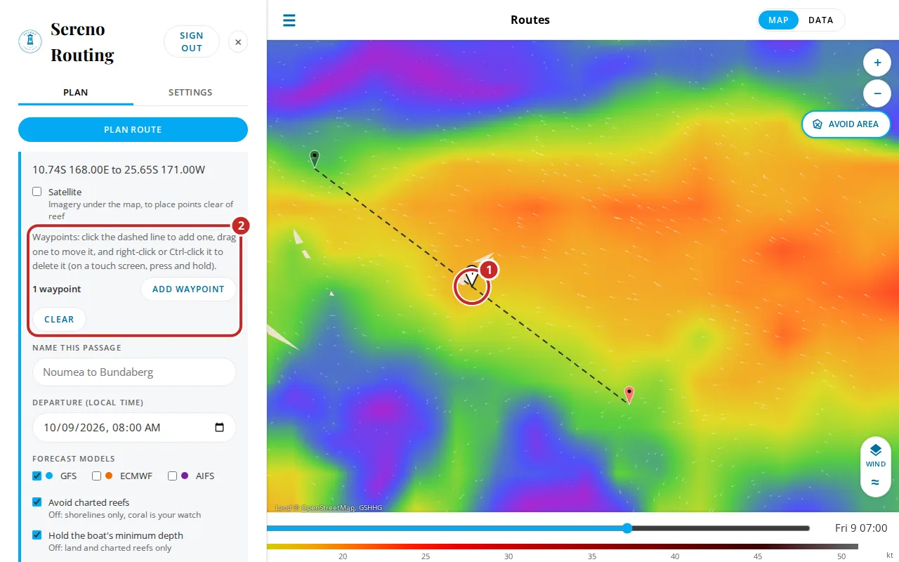
A waypoint makes the route pass through a point: round the right side of an island, through a pass you know, or to break a long passage into legs. A route takes up to 10, at least 1 nm apart.
On the web
- Add: click the dashed line between the pins, or tap Add waypoint and then the map.
- Move: drag it.
- Delete: right-click it or Ctrl-click it. On a touch screen, press and hold.
On the Android app
Once the start and finish are placed, the bar under the hint reads Tap the dashed line to add a waypoint, drag one to move it, and press and hold one to delete it. Add waypoint lets you tap the map instead (tap Done adding to stop), and Clear waypoints removes them all. Pins are numbered in order. Holding one asks Delete waypoint 2? with Keep and Delete.
Android, New route with two numbered waypoint pins on the dashed line and the waypoint bar showing "2 waypoints", Add waypoint and Clear waypoints.
Avoid areas
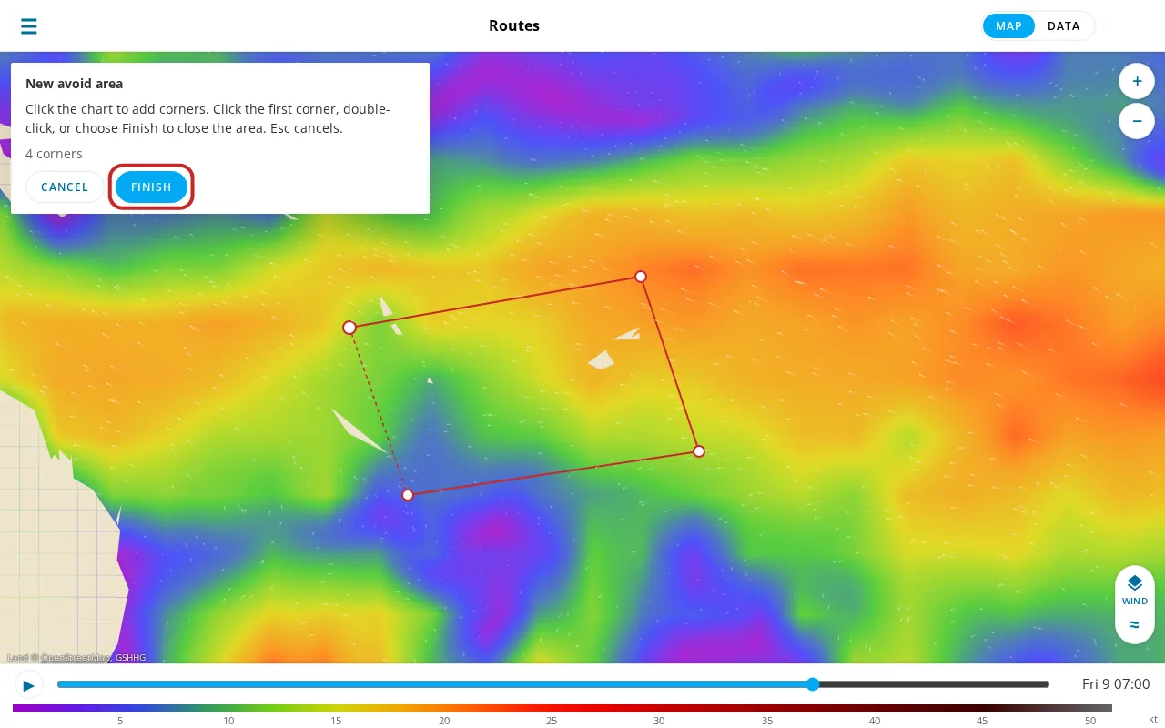
An avoid area is a shape that routes keep out of, as they keep off land: a military zone, a stretch of coast to stay clear of, a reef the charts miss.
- Tap Avoid area on the map (or Draw an area under Avoid areas in the Plan tab).
- Click the map at each corner.
- Close the area by clicking the first corner again, double-clicking, or tapping Finish. Then give it a name. Cancel or Esc stops without saving.
The Plan tab's Avoid areas list switches each one on or off, and edits or deletes it. Every route keeps out of every area that's switched on. A route already queued keeps the areas it was sent with. A start, finish or waypoint inside a switched-on area is refused, naming the area.
On the Android app, the round Avoid areas button lists them, with a switch, Rename and Delete for each. Areas are drawn on the web.
Edit, move and run again
A finished route can be run again in three ways. Each makes a new route, named with (2) after the original's name, and keeps the old one, so you can compare them.
- Rerun, latest weather in the routes list, or Run again in the route's bar: the same passage on the newest forecasts. If the departure has passed, it leaves at the next whole hour.
- Edit route on the map, or Edit in the routes list: the form opens filled in with the route's settings. Change anything and run it.
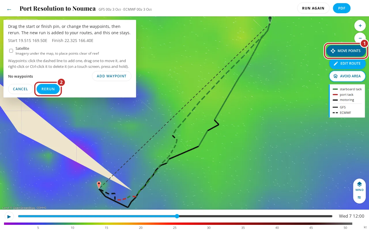
- Move points on the map: drag the start, finish or waypoints where they are, add or delete waypoints, then Rerun.
On the Android app: the route screen's edit icon (Edit and rerun), its refresh icon (Run again), and the round button Move the start, finish or waypoints. The iPhone app has the same edit and run again icons in the route's top bar.
All three sail your boat as it's set now in Settings: a change to the polar's percentages, the sailing angles, the motor or the limits applies to the new run. Only what you chose for that one route carries over from it, such as Sail only or a wind limit set just for that route. Edit opens with your boat's current figures and the route's own choices over them.
Rename changes a route's name without running it again. On the web it's in the routes list. On the Android and iPhone apps, it's in the route's top bar, or press and hold the route in the Routes list.
The start and finish check
Before a route is queued, the router checks that each end is in open water. An end on land, inside a reef, or in water surveyed shallower than your minimum depth is refused, and the form says why:
Not run: check the start. Your start at 19.52S 169.49E is inside the reef. Try starting at 19.57S 169.54E near Mock Pass, in open water toward the finish, and pilot out to it by chart.
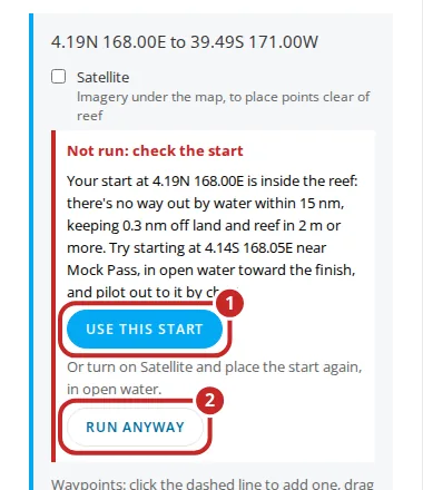
- Use this start or Use this finish moves the pin to the open water suggested. Check it, then tap Run route.
- The Satellite switch puts imagery under the map so you can see the reef and place the pin yourself.
- Run anyway sends the route past the check. The routes list notes that it ran past the check.
Plan to the water outside a pass, and pilot the lagoon by chart and eye. Inside reef, a router's data is at its weakest.
Automatic fixes
When a route stops short beside an obstacle, the router sometimes finds the fix itself and runs again. It keeps the new route only if it completes, and says what it did in the route's message, for example:
- Routed round Ile Ouen by 22.50S 166.90E. It added a turn point to lead round an island or reef. Your pins aren't moved.
- Started from 22.42S 166.38E near Dumbea Pass: pilot the first 4.2 nm by chart. The start was moved to open water.
- Finished at 16.98S 168.40E: pilot the last 3.1 nm by chart. The same for the finish.
Partial routes
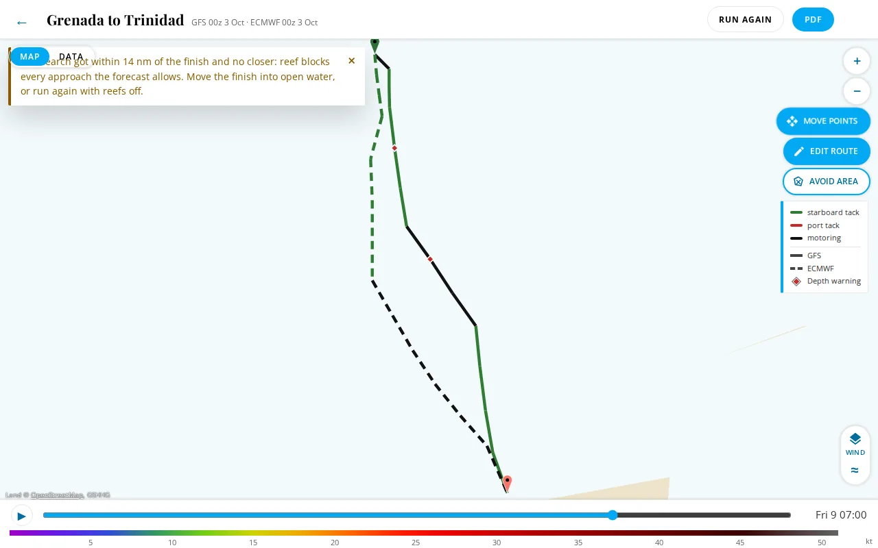
A route that can't reach the finish shows as far as it got. A dashed gray line joins its end to the finish, and a bar over the map says why it stopped and what to try. The routes list shows Partial GFS route: and the reason; the Boat page shows Stops 8.2 nm short.
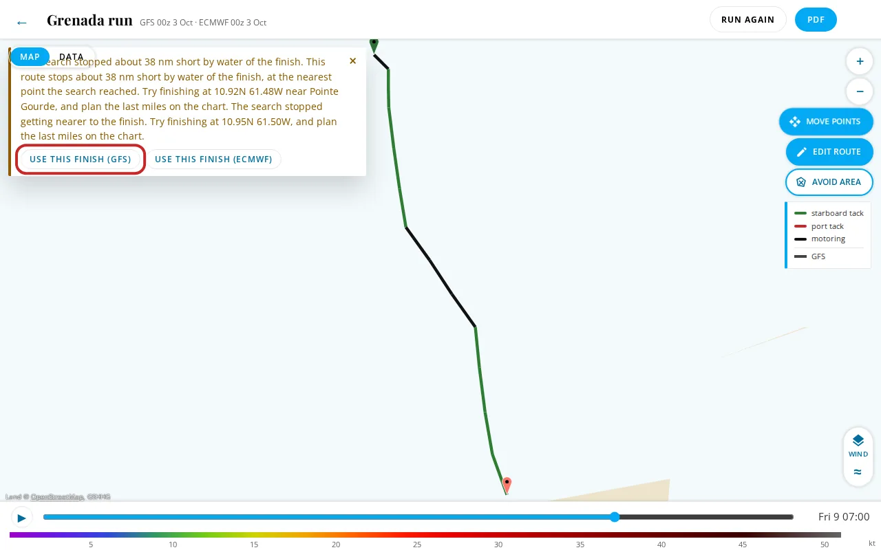
The bar's buttons each run a new route at once:
- Use this finish: finish at the open water the search reached or suggests, and plan the last miles on the chart.
- Use this start: the same for a start the search couldn't get out from.
- Use this waypoint: when there's a way round a reef or island far from the ends, a waypoint there.
When the models suggest different points, the button names the model, for example Use this finish (GFS). Other common causes and what to do are in What the messages mean.
When the forecast ends before the passage does, the route is planned as far as the forecast reaches and the rest is an estimate on the great circle, labeled No forecast: estimate on the map. Run it again later, as newer forecasts reach further. The warning bar says it once for every model that ran out, and Details opens each model's own reason:
The forecast ends Oct 27, so both routes stop short: 312 nm (GFS) and 280 nm (ECMWF) from the finish. The rest is an estimate arriving about Oct 30. Continue on climatology for October?
The bar's Continue on climatology runs the route again with that option on (see Past the forecast). Where climatology isn't held for the passage, the question is replaced by Run the route again as newer forecasts reach further.
Flagged routes
Every complete route is checked for steadiness: turns sharper than the boat would make, circling, zigzags under motor, the motor going on and off, tacks and gybes far more often than the wind shifts, or little headway for the miles sailed. A route that fails is flagged. It's still drawn, but the bar over the map says which stretch to distrust:
The route zigzags under motor around 10.95N 61.42W from 10-03 10:30 (14:30Z) to 10-03 12:10 (16:10Z) (5 turns of more than 60 degrees under motor). Try finishing at 10.90N 61.45W, before that stretch, and plan the last miles by chart.
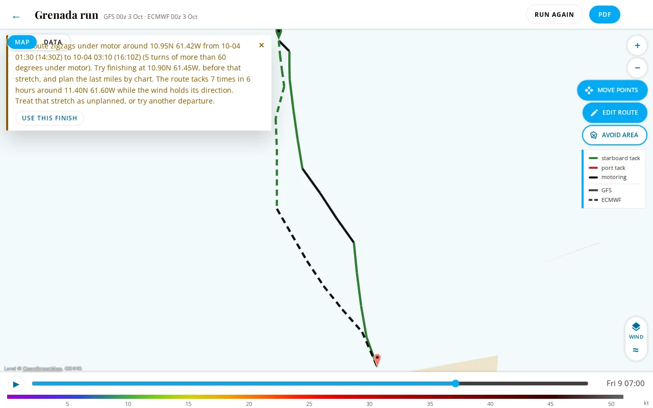
Near the start or finish, use the bar's Use this start or Use this finish. In the middle of a passage, treat the stretch as unplanned, or try another departure time.
Wind and wave limits
With a limit set, the route goes around wind or waves over it. If there's no way around, the route stops and says whose limit stopped it, and where and when it met the wind or seas:
Your boat's wind limit (25 kt, in Settings, Boat) stopped this route: on every way through, the true wind reaches 31 kt about 12 nm north of Tanna from 10-08 17:00 (06:00Z). Raise the limit, turn it off for this route, or try another departure.
A limit set in the form for this route alone reads This route's wind limit (25 kt) stopped it instead. When the same limit stopped every model, the bar says it once for all of them, with the highest wind or sea met and how far from the finish the routes end.
The bar's Raise the limit opens the route in Edit with the limit's field ready to change. When the models met different limits, there's a button for each, Raise the wind limit and Raise the wave limit. Saving runs the route again, as Edit does.
Set the boat's limits in Settings, Boat, and change them for one route in the form's Limits. Waves are significant height. AIFS has no waves, so a wave limit can't be held on it: route on GFS or ECMWF for that.
Past the forecast
A passage can outlast every forecast. By default the router plans it as far as the forecast reaches and draws the rest as an estimate. With Past the forecast: continue on climatology on, in the route's options or as the boat's default in Settings, the router carries on in the month's typical weather and plans the whole passage, round land and reef as usual. The warning bar offers the same switch when a route has run out of forecast, ending its summary with Continue on climatology for October? (see Partial routes). The button runs the route again with the option on, and keeps the first.
The typical weather is the month's median wind speed from the direction the wind most often comes from there, with the month's median seas, from ERA5, the European reanalysis of 1995 to 2024. It has no gales and no calms, so it's a sketch of the passage, not a forecast of it. You'll see which part is which:
- The summary says Days 1 to 15: forecast. Days 16 to 20: climatology for October, not a forecast.
- On the map the legs on climatology are faded, with a ring where the forecast ends.
- In the leg table they're shaded, and each says how often the month passes your wind and wave limits there: In October, winds here pass your 25 kt limit about 12% of the time. Your limits don't stop a route on climatology.
- The PDF boxes the same words on its first page, with the rule and ERA5's credit.
A newer forecast moves the split later, so Rerun, latest weather has fewer days on climatology. Ocean current stops where the current forecast does, as it does on any long route.
Ocean current
With Use ocean current on, the route sails the RTOFS surface current forecast as well as the wind, so it favors a fair stream and avoids a foul one. The routes list says what it found, for example GFS current up to 1.2 kt with you, 0.8 kt against.
The current forecast reaches about 8 days. A passage past its end is planned on wind alone from there. If planning with current leaves a route short of the finish or flagged, the router plans it on wind alone instead and says so: Planned without ocean current: with it, the search didn't reach the finish.
The Current layer shows the current on the map, and the Current tab lists it leg by leg.
Depth warnings
Routes keep to your minimum depth where the depth data is surveyed. Where a leg crosses data that reads shallower (often estimated near coasts and reefs), the route isn't refused, but it's marked:
Depth warning on 2 legs: depth data as low as 0 m (estimated, not surveyed) near Isake Passage; check the chart.
Red marks on the map show where, and those legs are tinted in the tables and the PDF. Tap a mark for its depth. Check each one against the chart.
Storm and disturbance notes
Every finished route is checked against the official storm forecasts and the router's own upper air disturbance indication, and a route that passes near either carries a note. A note never changes the route: the router finds the same route with the checks on or off, and it doesn't steer round a storm, hold back a departure or stop short because of one. Whether to sail is the captain's decision.
- Official storms. The forecast tracks of the tropical cyclone warning centers, as the Storms layer shows them. A route is noted when, at any time along it, the boat would be within 200 nm of where the center's track puts the storm at that time. The track runs from the advisory position through the forecast positions, in straight lines between them. Nothing is said for a time more than 3 h before the advisory or after the last forecast position, or when the router holds no reading less than a day old.
- Upper air disturbance. The router's own indication, read from the newest upper-air run of each model the route used: spin, a closed low, low shear, a warm core and the moisture and CAPE for deep convection, together (the rule is in Understanding: Storms and upper air disturbances). A route is noted when it passes within 250 km (135 nm) of an indicated area at a forecast step within 24 h of the boat being there.
The notes are fixed sentences filled in with the numbers. An official storm reads:
NHC advisory 25, issued Tue 15:00Z, has Hurricane Simon (75 kt) within 140 nm of the route near 21N 108W on Wed. It's the center's forecast, it can change, and the decision is the captain's.
The wind is the center's figure for the forecast time nearest the boat's closest pass. An upper air disturbance reads:
An upper air disturbance is indicated in GFS within 95 nm of the route near 14S 172W, Wed to Fri: spin of 9.1e-5 /s at 850 hPa, CAPE up to 1,850 J/kg, 700 hPa humidity of 78% and wind shear of 9 m/s, its spin strengthening. It's one indication among several, not a forecast, and the decision is the captain's.
The numbers are what the model read at the disturbance's center at the step nearest the boat: the spin at 850 hPa, the CAPE (the energy for deep convection), the humidity at 700 hPa, about 3,000 m up, and the wind shear between 850 and 250 hPa. Where the model publishes no CAPE (AIFS) the note says so. A weaker sign, with the spin, low, shear and warm core but not the moisture or CAPE, is never in the warning bar: it's listed in the PDF's details, with what it lacked, and ends On its own it doesn't indicate a disturbance.
It says on the route when the track crosses an indicated area, and its spin strengthening or weakening when, within the first day after it's found, the spin rises to 1.25 times its first figure or falls to 0.8 times. When more than one is near, the nearest storm or the strongest disturbance is named and the sentence adds and 1 more.
Where the notes show:
- The warning bar over the map, with the centers' credits under a storm note.
- The routes list, a line per model under the route, starting with the model's name.
- The leg table on the Data face: the legs the note covers have an amber mark at the left of their time, and hovering over the row shows the note. On the Android app, the legs near an official storm are shaded.
- The route PDF: a box on page one headed Official storm forecast, a note or Upper air disturbance, one indication. A disturbance, indicated or a weaker sign, also gets a line in Day by day for each day it's near the track, and the rule in How this was made, with the weaker signs' line.
The planner notes a departure day and its brief the same way; see Storms and disturbances on a day.