 Sereno Routing guide
7. Understanding the results
What a route is made from, where each part is weak, and what the messages mean.
Weather models and runs
Each model runs four times a day, at 00z, 06z, 12z and 18z (UTC), and each run is a forecast from that hour forward. A run takes hours to compute and publish, so the newest one held is always a few hours old.
| Model | From | Reaches | Steps | Usually here after the run |
|---|---|---|---|---|
| GFS | NOAA | 16 days | Hourly to 5 days, then 3-hourly | About 4.5 h |
| ECMWF | ECMWF's open data | 15 days from the 00z and 12z runs, 6 days from 06z and 18z | 3-hourly, then 6-hourly | About 8.5 h |
| AIFS | ECMWF's machine-learning model | 15 days | 6-hourly | About 8.5 h |
| RTOFS current | NOAA | 8 days, one run a day | Hourly to 3 days, then 3-hourly | Within the day |
All three weather models are on a 0.25 degree grid, about 15 nm. They don't see a squall, a wind acceleration round a headland or a sea breeze. AIFS has no waves.

The age line reads like GFS 00z, 9 h old; ECMWF 12z, 21 h old, late; AIFS 06z, 3 h old. late means the next run is overdue. A route uses the newest run held whose forecast reaches the planned arrival. For ECMWF that may be the longer 00z or 12z run even when a newer 06z or 18z run is held, and the route's warnings say so.
A forecast gets less reliable the further ahead it looks. Beyond about 5 days, treat a route as a sketch, and run it again as newer runs arrive.
Ensembles and spread
An ensemble is a weather model run many times at once from slightly different starting points. Where the runs agree, the forecast is settled; where they spread apart, it isn't. The planner uses two:
- ECMWF ENS, 51 members.
- GEFS (NOAA's GFS ensemble), 31 members.
For each departure day, the planner sails your boat along the safe path once on every member, 82 passages when both are in, in 15-minute steps with your polar, sailing angles, polar by day and at night and motor. It reports:
- The median and the range. 39 h, 36 to 44 is the median passage time, then the 10th and 90th percentiles: 8 in 10 passages took between 36 and 44 hours.
- Risk. The share of passages that pass your wind limit, pass your wave limit, or spend 3 h or more at Sick. The verdict follows those shares and the comfort levels (the day cards give the rules).
- Spread along the path. A band from the 10th to 90th percentile of the wind at each point, with the median as a line. A wide band means an unsettled forecast.
Gusts in the planner are worked out as 1.23 times the sustained wind, the factor used at sea, rather than taken from any model's gust field.
The ensembles are coarser than the single models, so the planner is for choosing a day. Route the day you choose for the detailed plan.
Polars
A polar is a table of boat speed for each true wind speed and angle. The router reads speeds between the table's figures, and a 0 means the boat doesn't sail there. Its routes are only as good as the polar: a builder's polar for a racing setup will be faster than a loaded cruising boat, and the route will be early.
The planner and the brief sail two bounds: your polar, and a conservative polar at 80% of it, day and night. The conservative one stands for a loaded boat, a foul bottom or seas that slow it. Your arrival will most often fall between the two.
Polar, by day and Polar, at night scale the polar. Each is a whole percentage of the polar itself, 50 to 150: 100% sails your polar, and 85% sails at 85% of it. The night figure replaces the day figure from sunset to sunrise, so a crew that reefs at night can set it lower, and a boat that keeps up with its polar can set both higher. If most of the figures in the polar are too high for your boat, set both lower. The conservative polar is 80% of whatever you set. The sailing angles keep the boat out of angles it won't sail.
When sailing would be slower than the Motor when sailing below speed on the best heading, the router motors at the motor speed. Motoring legs steer the direct course toward the finish along the safe path.
Comfort
Every step of a route gets the worse of two ratings:
- Wind over the deck: the apparent wind. Champagne under 12 kt, Easy under 18, Coffee under 23, Rough under 33, Sick above.
- Motion: how hard the boat moves in the sea. Each wave train (wind sea, swell and the short sea on top) is judged on its own and the worst decides. A sea on the bow moves a boat more than one from astern, and short waves move a long boat less.
A catamaran or trimaran gets extra for seas on the beam (roll) and seas over 1.5 m on the bow (slamming). A sea steeper than 1 in 20 rates Rough from any direction. That's why the ratings depend on the hull and length in Settings, Boat.
Period:height is the wave period in seconds per meter of height. A 2 m sea at 8 seconds is 4:1. Sailors use the feet version: 3:1 or better (period in seconds over height in feet) needs no thought, under 2:1 is worth thinking hard about, and 1:1 is a square sea.
The comfort model is a first guess, not yet checked against logged passages. Use it to compare days and routes rather than as a forecast of how the trip will feel.
Current
The current is NOAA's RTOFS ocean model, at about 5 nm, one run a day reaching 8 days. It gives the ocean currents and eddies. At that grid it can't show the streams in passes, harbors and close inshore: check those in your tide tables and pilot books.
A route with current shows how much ran with you and against you. If planning with current leaves a route short or unsteady, the router plans it on wind alone and says so.
Depth, reef and land data
- Land is the GSHHG world shoreline. At best it's good to a few hundred meters, and small islands and rocks can be missing.
- Reefs are the UNEP-WCMC charted reef shapes, fetched for each route's corridor when Avoid charted reefs is on. Not every reef is charted.
- Depth is GEBCO, in cells about 460 m across. Some cells are surveyed, many are estimated, and near coasts and in lagoons it often reads shallower than the water is. That's why the minimum depth works best at about twice your draft, why estimated cells only warn rather than block when reefs are avoided, and why a route may refuse to go through a pass you know is deep enough.
None of this replaces a chart. Near land, plan to the open water outside a pass and pilot the rest by chart and eye.
Storms and upper air disturbances
Two sources say what may be developing. Both give notes only: nothing from either goes into a route's search (see Storm and disturbance notes).
Official storms are the warning centers' own advisories, read about every 6 hours: NOAA's National Hurricane Center, the Japan Meteorological Agency, the Joint Typhoon Warning Center and the Fiji Meteorological Service (RSMC Nadi). What each gives is in the Storms layer. They're the centers' forecasts as issued, and they change with each advisory. RSMC Nadi's advisories reach 24 h ahead. Where Nadi and JTWC both track a storm, Nadi's is the one shown and checked, so in the southwest Pacific a route is checked against that storm for about the first day only.
An upper air disturbance is the router's own indication, read from the models' upper air. Forecasters look for several things at once before they expect a low to organize: spin near the surface, moist air through the middle of the atmosphere, little wind shear, warm water and the convection to feed it. Any one alone is common and means little. The indication asks for these together, between 30 degrees south and 30 degrees north:
- spin: the relative vorticity at 850 hPa, averaged over a 150 km box, of at least 8e-5 per second, turning the way lows do in that hemisphere;
- a closed low in the sea-level pressure at least 2 hPa deep within 250 km, lasting 36 hours or more;
- over half that life, wind shear between 850 and 250 hPa at its center of at most 25 m/s, and a warm core: the 500 hPa temperature within 200 km of its center at least that of the ring 400 to 700 km out;
- and, over half that life, the convection: humidity at 700 hPa within 200 km of at least 72%, and CAPE within 500 km (its 90th percentile) of at least 150 J/kg. AIFS publishes no CAPE, so its disturbances are judged on humidity alone.
One that has everything but the convection is a weaker sign. It's listed in the details (the PDF's day by day and how it was made, the brief's line under its note), never in the warning bar or on a planner day.
CAPE is the energy a rising parcel of air can gain, so it says whether deep showers and squalls can grow. It doesn't say they'll organize around a low, and the tropics hold plenty of it most days. Tried on its own as a limit, it dropped real systems: a mature system has used up much of the CAPE near its center. The moisture at 700 hPa tells a developing system from a passing low better. So the rule uses CAPE as a floor and humidity as the main test.
The rule was chosen on ten years of ERA5, the European reanalysis, against IBTrACS, the world's record of tropical cyclone tracks, 2015 to 2024. The indication was within 300 km of 97.6% of the record's points with winds of 64 kt or more and 81.3% of those at 34 to 63 kt, and about 22 a year worldwide were far from anything the record lists (34 before the convection test). Within 1,500 nm of Fiji that's about 5 a year (7 before), 4 of them from December to March. Most depressions aren't caught. On archived GFS forecasts, rules like it found fewer systems the further ahead the forecast looked: about 8 in 10 a day ahead and about a third five days ahead, since a model's vortex is weaker at range.
A note is one indication among several, not a forecast. The official advisories come first: where a center is tracking a storm, its forecast is the one to read.
What the messages mean
A route that fails or falls short says why, where and what to try. These are the common ones. Times in them are in your device's time zone with UTC in brackets, for example 10-08 17:00 (06:00Z), and positions are latitude and longitude.
| The message starts | What it means | What to do |
|---|---|---|
| Not run: check the start / finish. Your start at … is inside the reef / on land / in water surveyed at under 2 m. | The start and finish check refused an end. | Use this start or Use this finish, or turn on Satellite and place it in open water. Run anyway sends it as it is. See the check. |
| Wind forecast does not cover the route endpoints or requested time. | The departure, or the passage at a slow pace, runs outside the forecast held. | Choose a departure inside the next two weeks, or add waypoints and plan a long passage in stages. |
| departure … is before the newest … run held here | The departure is earlier than the forecast starts. | Depart at or after the time it gives. |
| The forecast ends …, so the route stops … nm short of the finish | The route is planned as far as the forecast reaches; the rest is an estimate. | Use it as a sketch and run it again as newer forecasts reach further, or Continue on climatology. See Partial routes. |
| The search stopped getting nearer to the finish … | The search got stuck close to the finish, usually beside reef or land. | Use this finish, or set the finish in open water and plan the last miles on the chart. |
| The search stopped … with the motor allowed, so wind wasn't what held it: it couldn't find a way through the reef … | Reef, land or shallows block every way in. | Finish just outside the pass and pilot in; or add a waypoint that leads round. |
| The route couldn't get past the … and stopped about … nm short | Stuck far from the finish behind an island or reef. | Use this waypoint if offered, or turn on Satellite, find the way round, add a waypoint there and run it again. |
| … in open water, with nothing in the way where it stopped: the passage outran the search. | A long passage used up its search before the finish. | Add a waypoint partway so each leg is searched on its own. |
| Under sail alone this passage could not be completed … | With the motor off, the wind doesn't get the boat there in time. | Allow the motor, or try another departure. |
| The router found routes to the finish, but each crossed water shallower than the … minimum depth | The depth data reads shallow in a lagoon or pass. | Finish just outside the pass, or plan with reefs on. |
| Your boat's wind limit (… kt, in Settings, Boat) stopped this route / This route's wave limit (… m) stopped it | The limit can't be kept on any way through. | Use Raise the limit in the bar, turn the limit off for this route, or try another departure. See Wind and wave limits. |
| AIFS holds no wave forecast, so the … wave limit can't be held on it. | AIFS has no waves. | Route on GFS or ECMWF, or turn the wave limit off for this route. |
| The route zigzags / turns back on itself / sails in circles / makes little headway / switches the motor on and off / tacks and gybes far more often than the wind shifts … | A flagged route: complete, but that stretch is unsteady. | Near an end, use the suggested start or finish. In the middle, treat the stretch as unplanned or try another departure. See Flagged routes. |
| NHC / JMA / JTWC / RSMC Nadi advisory …, issued …, has … within … nm of the route | A warning center's forecast track passes near the route while the boat is there. The route isn't changed. | Read the center's latest advisory and look at the Storms layer. The decision is the captain's. See Storm and disturbance notes. |
| An upper air disturbance is indicated in … | The model's upper air shows spin, a closed low, low shear, a warm core and the moisture and CAPE for deep convection near the route. It's one indication among several. The route isn't changed. | Look at the Disturbance and Storms layers, read the official outlooks, and watch it on later runs. The decision is the captain's. |
| Storm forecasts couldn't be checked for this route. | On the Android app: the router held no reading from the centers less than a day old. | Check the centers' advisories yourself. |
| Depth warning on … legs | Some legs cross depth data shallower than your minimum. | Check those legs on the chart. |
| Routed round … / Started from … / Finished at … | The router fixed a near miss itself. | Pilot the miles it names by chart. |
| Planned without ocean current: … | Current wasn't used, and why. | Nothing, unless you turned it off by mistake. |
| The search stopped near your avoid area … | An avoid area may be in the way. | Switch it off or redraw it smaller. |
| this token already has 3 routes queued or running | Each person can have three routes queued or running at once. | Wait for one to finish, or delete a queued one. |
| the router has 12 routes queued or running … | The router is busy. | Try again in a few minutes. |
| the router restarted before this route finished | The route was lost in a restart. | Run it again. |
| no polar: none is chosen in Settings … | No polar is chosen. | Choose one in Settings, Polar. |
| Your sign-in has ended. Sign in again. | The browser's sign-in expired. | Sign in with your token. |
The Saillogger card
If your boat reports to Saillogger and you've set Saillogger boat in Settings, Boat, the Boat page's Sereno One card shows its latest public report: on passage (with speed and course) or at anchor (with the anchor's position and swing), the time of the last report, and the position with the nearest place name. Sereno reads it at most every 10 minutes while you're using Sereno. Reports reach Saillogger when the boat has a connection, so they can lag after an outage. Tap the card to open the boat's Saillogger page.
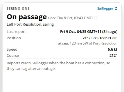
On the Android app, the same card heads the Routes list.